Kissena Forum Archive

Road & Bridge Conditions-H20, Dirt, Glass, Paving, Closures, etc

309 comments · 3345 views
First, I went to River Road yesterday.  It's still officially closed, but I'm guessing no one is watching it on weekdays.

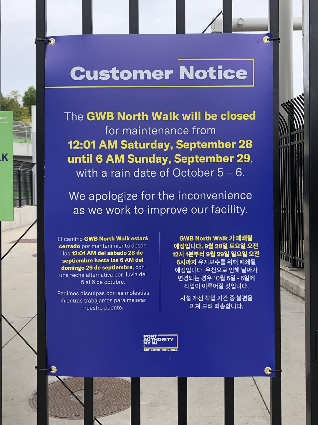
Second, this is big, bad news.  The folks at NYCC have September 28 as teh Escape from New York Century.  No idea what's going to happen.

All the more reason to ride to montauk that weekend
It doesn't say, but maybe one can use the south path? but also, what Mark said
All the more reason to ride to montauk that weekend
It's written in the stars
https://www.westsiderag.com/2024/09/24/hudson-river-greenways-cherry-walk-is-closed-for-six-months
The NJ transit /port authority website says it’s October 4th now 
anyone here any thing further on GWB 
The NJ transit /port authority website says it’s October 4th now 
anyone here any thing further on GWB 
My contact at NYCC said the bridge closure was no longer in effect this Saturday, as they have their huge Escape from New York ride going over the bridge on Saturday.  
Nice to hear that the port authority listens to that 
In the bad news department, a portion of the West Side Greenway, from 97th to 125th will be closed for the next six months.  

Great job by the city on outreach and planning alternatives.  not.

I looked into the numbers. there are, probably, at most 1000 parking spots on Riverside Drive between 97th and 135th streets.  With 7,000 people a day using the Greenway, it should be a no brainer to cut out parking.  of course that wasn't even discussed.

https://nyc.streetsblog.org/2024/09/23/not-acceptable-uptown-greenway-to-close-for-6-months-without-safe-detour
@JohnMalcolmson posted this on the thread earlier this week
I rode River Road to the Great Wall closure yesterday. I couldn’t see much up the road and the barriers and signs made it look like it was dangerous, but then an older lady rode down the Great Wall climb on a hybrid bike. She had an iPad strapped to her handlebars, was talking on headphones, and appeared to be conducting a Zoom meeting while riding. So, if she’s riding over the landslide, can it be that dangerous to try and ride past? Has anyone seen it in person recently?
We rode it shortly after it was closed.  It's not too bad and is only closed up till the picnic area.  The climb is pretty ripped up but the descent wasn't bad.
FWIW, there's going to be a half-marathon on River Road this Sunday.  They are taking the hill both ways.  
Bridge opens 6:00am Sunday (today). 8am GW anyone? 
https://www.nytimes.com/2024/10/16/nyregion/nyc-marathon-bicycle-race.html

New York Marathon Cracks Down on Cyclists’ Pre-Race Joyride

Last year, race officials say, a cyclist hit a pedestrian on the early-morning ride. This year, those attempting to ride the route will be removed.

eloy said:
https://www.nytimes.com/2024/10/16/nyregion/nyc-marathon-bicycle-race.html

New York Marathon Cracks Down on Cyclists’ Pre-Race Joyride

Last year, race officials say, a cyclist hit a pedestrian on the early-morning ride. This year, those attempting to ride the route will be removed.

Read that and noticed they alluded to the bike rider involved as being someone who was treating it like a time trial, which... this is why we can't have nice things.

"Some riders were saddened to lose a beloved yearly ritual. The ride, they said, was something organic in a city where many public events have come to feel overly costly or contrived.

Others were angry, placing the blame on what appeared to be a growing group of riders who pedaled aggressively and treated the event as a time trial, putting the safety of volunteers and pedestrians at risk."


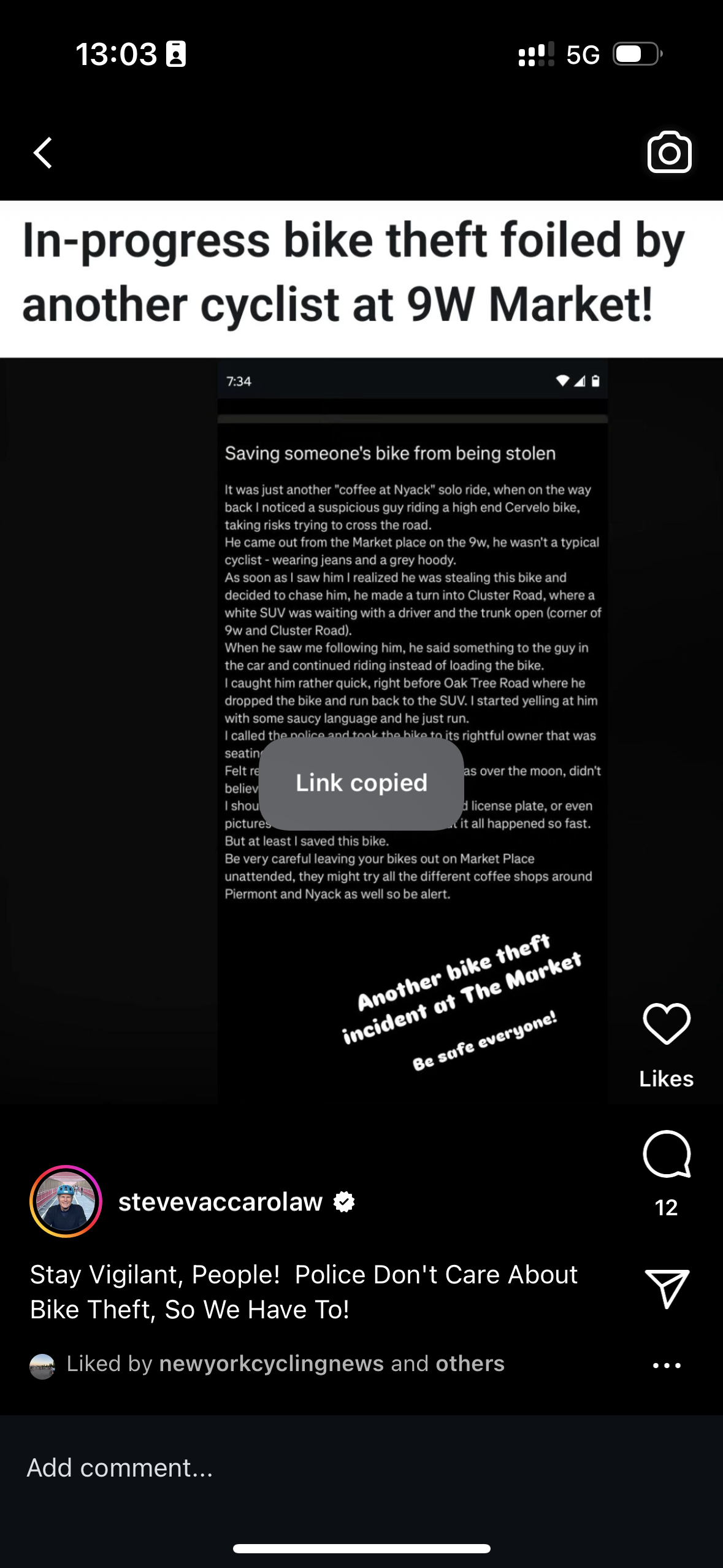
Careful with bike parking! 
 
Remember last year when an engineering firm was soliciting input for redesigning the Central Park Drives?

The report is finally out.  

https://www.centralparknyc.org/drives

The link above is their press release on it.  In the press release, you'll find a link to the PDF.

The PDF is here: https://s3.amazonaws.com/assets.centralparknyc.org/media/documents/FINAL-Drives-Report_2024.10.21-2.pdf

  To me, it's unclear exactly how they will proceed. But, in broad strokes, a number of the suggestions put forth seem like good ones.  It seems as if they will be, as I suggested they should, making an effort to draw pedestrians to take the archways under the drives whenever possible.  
Thanks for sharing JP -- I just sent a note to the PPA about it, noting that none of the future proposals include pedestrians on both side of the drive, they all have pedestrians only on the inside of the drive.  
Re: Congestion pricing - My office sits at 57th/Madison right along the route to/from the Queensboro Bridge and I usually walk or ride my brompton from Grand Central to commute. Yesterday I had to run a few errands around midtown and UES. I noticed a dramatic reduction in avenue and street traffic during rush hour, even as there were packed sidewalks of people. Anecdotally my LIRR train along the north shore (Port Washington line) was more packed than usual even accounting for the usual commuters for common "in office days" of Tues/Wed/Thurs. The conductors have also been extremely diligent in checking and scanning train passes compared to the last two years when they've been generally lax.

All this is to say the system is working and I hope like hell this generates more revenue to bulk up mass transit and protected bike lanes around here. 

Sadly my city council member was the one who recently suggested motorists vandalize the license plate scanners and cameras. I feel for some of the folks around here in transit deserts but there is a pretty solid bus system and guess what always holds up bus traffic? Local drivers who are used to driving a few blocks to get groceries or eat out at restaurants - which some of them have those semi-legal valet services and clog up the boulevard with double parked cars.
@David Yang

This gets my head back to when I was agitating to get Morningside AVenue redesigned.  The local CB, which was dominated by car owners, and the transporation committee head drove everywhere, were complaining that not only would they lose parking spots with the redesign (they didn't), but that it would be harder to double-park.  I was told Harlem had "a driving culture," even though less than 18% of the residents owned cars.  When it came to Citibike, they were also bitterly opposed, even though the median income at the time was around $38,000 a year, which is hardly enough to pay rent and other living expenses, let alone the money to own and maintain a car.  Even though housing project residents would have to pay only $60 a year to use Citibike.  Arrrrgh!

I can't find the exact stat at this moment, but the median income of car owners in NYC is north of $80,000 a year, while the median income of non car owners is closer to $40,000.  

As for those people complaining about driving in from the burbs to see a show or eat a meal, "the average household income of a suburbanite who goes to Broadway is $294,000. "Twenty-eight percent of the audience reported an average annual household income of $250,000 or above, compared to 7 percent of the U.S. population," the Broadway League said in its most-recent demographic report (which we had to pay for!).

The average ticket price for a show is $161.20, meaning if four New Jersey residents get in a car to see a show, the additional $6 congestion toll they'll pay represents 0.9 percent of their theater costs, before even calculating in food, parking, souvenirs and maybe a post-show drink at Sardi's."

Furthermore, and to further poke holes in your councilman's complaint, "Additionally, drivers making less than $50,000 per year can register their vehicle with the MTA to get a 50-percent discount on the peak toll for every trip into lower Manhattan each month after the 10th full-fare toll."


https://gothamist.com/news/nyc-to-overhaul-central-park-loop-to-limit-conflicts-between-bikers-walkers-and-runners

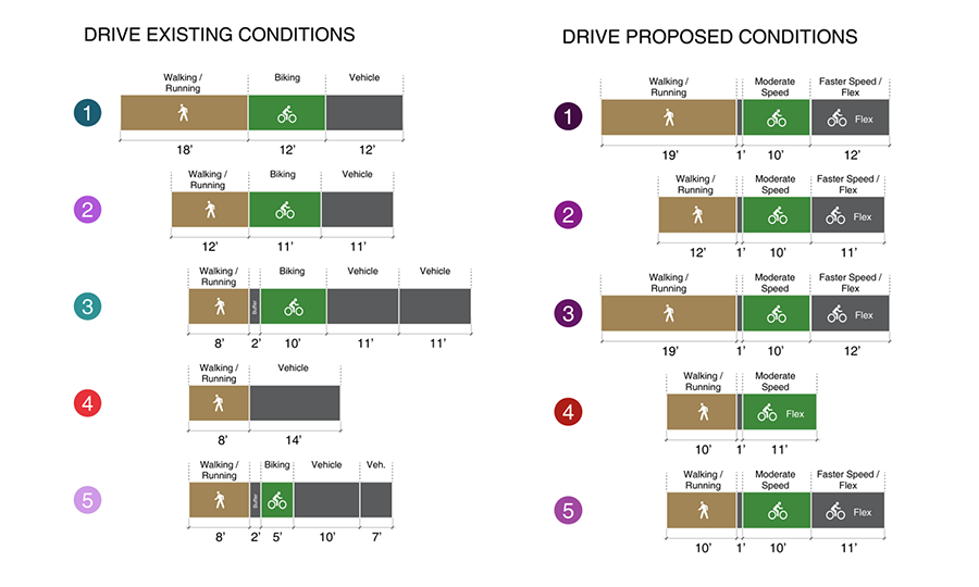
I... wonder if these people have ever been in central park? This is the current layout, right?


“There's going to be an inside lane for pedestrians and joggers. There'll be a middle lane for slower bikers and then a speedier lane on the outside, which is reserved for emergency vehicles, for work vehicles, but also for all the e-vehicles that are now very much in the park," he said.
That's basically the current layout, yes. 

The distiction is that all the current lines were designed for cars, this makes it so the the right side is "officially" a bike lane. 
Looks like they have some extra cash they need to spend before the end of the fiscal year.

https://www.nyc.gov/html/dot/html/pr2025/redesign-central-park-drives.shtml


https://bettercities.substack.com/p/congestion-pricing-is-a-policy-miracle

In the first month of congestion pricing, the MTA reported over 1 million fewer vehicle entries into the toll zone than would be expected without the program​

It looks like river road is open again? Can anyone confirm?
Looking at Strava it's been open enough for 700 riders to have done it this year. From what I've heard you just don't want to do it southbound because you'd be going downhill on the worst part in terms of road quality. 
Makes sense: judging by social media videos, it looks like they cleared the dangerous debris from the Great Wall climb but have not repaved it. I’ve ridden up it after the damage and it was fine going uphill, but yeah likely not very safe to ride downhill at speed.
I've done it a bunch of times this year.

It is closed.

The first closure is at the foot of the hill in Englewood Cliffs. You'll likely have to get off your bike here. Then, you climb on a clear road that is mostly exposed brick.  Descend the other side, and you come to another fenced off area.  This you'll likely be able to ride.  Then, the gate at Alpine.  You can ride that.


Hey peoples,   there is a public meeting about the Palisades Shared Bike Path Study in two weeks.  Three actually, but only one is via a web meeting

https://www.palisadespathstudy.com/

April 15, 6:00 pm - 8:00 pm
Join virtually
https://meetny-gov.webex.com/meetny-gov/j.php?MTID=mf879add71bc3ee9372279834fad4cc3d


About the Project

The Palisades Shared Use Path Study is a project to explore the feasibility of making connections between the George Washington Bridge in Fort Lee, New Jersey to the Governor Mario M. Cuomo Bridge in South Nyack, New York more intuitive, and more accessible for people walking, biking, running, and rolling. The Palisades Shared Use Path Study area extends about 20 miles along the west side of the Hudson River, traversing busy roadways, historic downtowns, and public parklands, including Palisades Interstate Park and Tallman Mountain State Park.

Where is the Palisades Shared Use Path Study area?

The study area extends from the George Washington Bridge to the Governor Mario M. Cuomo Bridge, traversing the city of Englewood, and the Boroughs of Englewood Cliffs, Tenafly, and Alpine in New Jersey.  In New York, it passes through the Town of Orangetown (including the Hamlets of Palisades, Sparkill, Orangeburg, and South Nyack) and the Villages of Piermont and Grand View-on-Hudson. The corridor follows the Palisades Interstate Parkway and U.S. 9W - the southernmost portion of New York State Bicycle Route 9 - which connects New York City to Rouses Point on the Canadian border.

Why is this study happening now?

The completion of the Governor Mario M. Cuomo Bridge shared use path created a new crossing over the lower Hudson River for walkers and bikers for the first time in nearly 90 years. Before this path opened in 2020, the closest crossing to the George Washington Bridge was the Bear Mountain Bridge, nearly 40 miles to the north. This new crossing, along with the ongoing upgrades to the George Washington Bridge shared use paths, are expected to increase bicycle traffic along the U.S. 9W corridor between these two bridges. This study will explore the feasibility of making connections safer, more intuitive, and more accessible between the two bridges, as well as the feasibility of other enhancements for various users along the U.S. 9W corridor through Palisades Interstate Park.

Study Objectives

The objectives of this study are to explore the feasibility of making connections between the George Washington Bridge and the Governor Mario M. Cuomo Bridge safer, more intuitive, and more accessible for people walking, biking, running, and rolling.

  • Explore the feasibility and potential benefits of improving connections for various users, by assessing the physical and social characteristics of various routes.

  • Identify how the corridor can be improved, considering factors such as safety, environmental impacts, proximity to parks, businesses and other key destinations, and connectivity to other paths.

  • Engage with local residents, business owners, government agencies, and advocacy groups to gather input, address concerns, and build support for the study.

Study Outcomes

  • A determination of overall project feasibility. Feasibility will be determined based on a variety of factors, such as topography, community character, safety, and balancing the needs of various users.

  • A final recommendation that accounts for connections that can be made safer, more intuitive, and more accessible.

  • Opportunities for amenities, gathering spaces, and aesthetic elements will be identified.

  • A documented implementation plan and next steps will be created and distributed.

  • Design-planning requirements and cost estimates will be identified and announced.